Search
Search Results
-
Review of research on salt-affected soils in the Debrecen agricultural high educational institutions, with special focus on the mapping of Hortobágy
471-484Views:231The history of the research of Debrecen scholars on salt-affected soils of Hortobágy and the region is very rich and diverse.
Focusing on mapping, the following stages can be distinguished, indicating the completeness of the maps and the purpose of the performed work
− First, quantitative maps (Arany, 1926) for the utilization of the lands at 1:75,000 (Figure 1).
− Second, quantitative map (Kreybig, 1943) for the utilization of the lands at 1:25,000.
− Third, category map (Kreybig et al., 1935) testing the suitability of the classification system at :75,000.
− Fourth, partial category map (Szabolcs, 1954), showing the reasons of unsuccessful management at 1:10,000.
− Fifth, partial quantitative map (Csillag et al., 1996), showing the utility of digital sampling at 1:25,000.
− Sixth, partial quantitative map (Tamás and Lénárt, 2006), showing the capacity of multispectral remote imagery at 1:100.
− Seventh, partial quantitative map (Douaik et al., 2006), showing the usefulness of geostatistical mapping at 1:10,000.
− Eight, national quantitative maps (Pásztor et al., 2016), showing the applicability of geostatistics for administrative purposes at 1:10,000.
− Ninth, partial quantitative/category map (authors, 2019), finding the optimal methods at 1:10,000. -
Visualization techniques in agriculture
95-98Views:413This paper describes a dynamic map representation method which provides a flexible, spectacular and cost-effective opportunity for the illustration and description of spatial data due to its parametrability, web-based publication and the free sowftare it uses in multi-user circumstances.
The tasks of the database serves and the processing were performed by an ASUS WL-500 G Premium v2 router and a 80 GB hard disk. The database contains the measured data of the nitrogen fertilisation experiment established on the Látókép Experiment Site of the Centre for Agricultural Sciences of the University of Debrecen. The tests showed that the generation time of the processor which was run through the router did not significantly increase. Therefore, the configuration developed by us is suitable for users who do not wish to invest into a large and expensive server, but they still want to view their data quickly and easily, as well as to reach them from anywhere.
The available data were not sorted into a database which was performed with Quantum GIS in a way to have an optimum database structure which is adjusted to the expected areas of use and the expected running speeds were also taken into consideration. The processor which processes the database items was written in PHP language. The main role of the processor is that it produces a KML file real time which is suitable for viewing with a given map viewer client (e.g. Google Earth). This application makes it possible to view information related to geographical objects, values stored in the database or those calculated by the processor on a map in 2D or 3D in a versatile way.
-
Establishing regional cultivating districts on the basis of the Kreybig practical soil mapping system
20-25Views:551With the help of this report evaluating the current situation of the region, characteristics of the development in agricultural production and regional differences can be clarified. By mapping out the regional soil, land use and climatic conditions and organizing these into a geographical information system, one can easily determine which plants are the most ideal to cultivate in that particular region. Moreover, it is a useful tool that enables us to
establish the most favorable land use structure suited to ecological demands and also helps to determine the methods of soil protection.
During our work, we chose administrative units in Szabolcs-Szatmár-Bereg County, based on the latest aspects of regional cultivation.
Our pilot areas are: the small regions of Nyíregyháza, Nyírbátor, Nagykálló, Mátészalka and Csenger.
Using the database, we separated and uncovered the soil conditions of the pilot areas: the chemical and physical properties of the soil layer which is exploited by the roots of the plants, the humus content, the nutrient supply, the thickness of the cultivated layer and the water management conditions.
We separated the districts of regional cultivation, where the basic elements of the traditional Kreybig color systems were applied (light yellow, dark yellow, light brown, dark green, blue, pink, red, gray, greenish brown, reddish purple, light purple, dark purple, light green).
By using the data collected from the pilot areas, we compiled a map database, which is suitable to illustrate the plant cultivating characteristics of the region. We made recommendations to determine the most favorable plants to cultivate in the specific region with the given meteorological and soil conditions, as well as for the shifting of crops.
Our recommendations were also illustrated in a map with a resolution of 1:25000. -
Development opportunities for storing and displaying of spatial data in long-term experiments
81-86Views:316Long-term experiments are required to evaluate the impact of irrigation, nutrient utilization, and year factor as well as to assess the potential consequences of climate change. However, in the long-term experiment, it may be necessary to display spatial data for each parcel, either for investigation of soil heterogeneity or presentation. This article aims to provide help for researchers working in long-term experiments for storing and displaying spatial data.
After the outlines of each experimental site were measured with GPS, a spatial database has been created in Quantum GIS. Then, a filter script in R statistical environment using RStudio graphical interface was written. The script helps avoid the QGIS data input interface so that large data can be attached to each parcel directly and as a result there is no need for a separate data entry, only the basic statistical database.
The created GIS database can be used in many ways; it can be exported to KML file format that can be displayed using Google Earth. It is possible to view exported KML files in Google Drive with importing them to Google My Maps application, and with that a browser can display the map. With the Google Drive the maps can be shared within the research group, additionally the outlines can be edited and it is possible to upload the measurement data to the attributes table to existing empty table columns. The map created in Quantum GIS can be used for presentation purposes.
-
The Development of a Plot Fertilizer and Distributor, Analyses of How it Works
35-38Views:225stribution of the different types of fertilizers is essential. In my study, I recommend a solution for the mechanization of fertilizer distribution on probe parcels. I have designed and constructed a new plot fertilizer distributor. This machine of moderate price can be controlled easily; it provides accurate distribution and versatility. In my paper I give an outline of its basic principles of operation.
The spreading pattern of the complete plot fertilizer distributor was investigated on the top of a test-desk. I constructed a test-desk, which has 16 collecting trays in transversal direction and 1o collecting trays in longitudinal direction. I developed a new method for data interpretation. A map of distribution was designed to process the data of the measured 16o trays. In the distributor, a map precisely traced the pattern of granule distribution and the amount of fertilizer as well. After this, I defined the transversal and longitudinal coefficient of variations for spreading. On the basis of my investigations I can conclude that the plot fertilizer distributor has excellent, even spreading (longitudinal and transversal) patterns. -
Usage of Different Spectral Bands in Agricultural Environmental Protection
123-126Views:249Hyper and multispectral imaging systems are widely used in agricultural and environmental protection. Remote sensing techniques are suitable for evaluating environmental protection hazarsd, as well as for agriculture resource exploration. In our research we compared aerial hyper and multispectral images, as well as multispectral digital camera images with the background data from the test site. Hyperspectral records were obtained using a new 80-channeled aerial spectrometer (Digital Airborne Imaging Spectrometer /DAIS 7915/. We have chosen two farms where intensive crop cultivation takes place, as test sites, so soil degradation and spreading of weeds can be intensive as a result of land use and irrigation. We took additional images of air and ground with a TETRACAM ADC wide band multispectral camera, which can sense blue, green and near infrared bands. We had detailed GIS database about the test site. Weed and vegetation map of the area in the spring and the summer was made in 2002. For soil salt content analysis, we gathered detailed data frome an 80x100 m area. When analyzing the images, we evaluated image reliability, and the connection between the bands and the soil type, pH and salt content, and weed mapping. In the case of hyperspectral images, our aim was to choose and analyze the appropriate band combinations. With a TETRACAM ADC camera, we made images at different times, and we calculated canopy, NDVI and SAVI indexes. Using the background data mentioned above, the aim of our study was to develop a spectral library, which can be used to analyze the environmental effects of agricultural land use.
-
Examination of different grain hardness varieties of the grinding technology properties of wheat
423-435Views:374In the mill industry, the purpose of the grinding technology is to separate wheat endospermium and shell and to recover grists. The most important and the highest energy requirement operation is shredding. Flour quantity and quality produced from wheat depends on the variety of wheat that will be shredded, the type of grinding equipment and the condition used before the grinding. For this reason, during my experiments, I ground two grain structured varieties of wheat in laboratory conditions using a disk grinder, stone grinder and roll grinder in air-dry and conditioned states. We measured the equipment’s performance and the produced grist’s particle size distribution, followed by the calculation of the energy requirements of the grinders. In the grinding experiments we compared the ash contents of the different particle sized grist’s fractions to map the wheat’s particular properties.
-
Possibilities of mass valuation in land use in Hungary
59-68Views:400Technological development makes it possible to simplify and accelerate decision-making processes by adequately processing and evaluating large volumes of data. Sub-data obtained from large data sets have a very important practical role in asset valuation, forecasting and valuing delineated or difficult-to-map areas, or in the context of portfolio management. Land valuation is a separate segment within asset valuation and it requires a specific methodological approach on behalf of evaluators. In this study, the authors compared the transaction data of arable land and the value of other land use categories. Based on empirical assessments, the authors developed proposals for the fast and cost-effective determination of the value of land use categories other than arable land - mainly meadows and pastures.
-
Mapping agricultural performance and environmental parameters aimed at generic regional studies
29-34Views:609In this paper we present the interim results and the methodology applied to create web GIS ready cartographic representations of agricultural performance related information and environmental parameters. The main aim of the research is to eventually create a web GIS based decision support system that can enable decsision makers and general users to create useful and representative map layouts of certain environment and agriculture related phenomena that can be easily analyzed and interpreted to make strategic decisions on environmental issues. In this aim the initial steps are to evaluate the available data for cartographic representation, analyze the possibilities of visualization, create a GIS ready data structure and implement the database and revise additional possibilities to incorporate further environment related datasets of auxiliary sources. The main results of the study are a comprehensive set of visual layouts that could serve as guideline for mapping statistical information of agriculture and some steps towards the incorporation of environmental parameters to the system.
-
Evaluation of Soil Degradation Based on High Resolution Remote Sensing Data
145-148Views:471Soil salinity is the main problem of soil degradation in the Grate Plain with cultivated area of 20% affected. Its influence is accelerated on the water managed and irrigated lands. Remote sensing can significantly contribute to detecting temporal changes of salt-related surface features. We have chosen a farm where intensive crop cultivation takes place as a test site as soil degradation can be intensive as a result of land use and irrigation. In order to evaluate soil salt content and biomass analysis, we gathered detailed data from an 100x250 m area. We analyzed the salinity property of the samples. In our research we used a TETRACAM ADC multispectral camera to take high resolution images (0,2-0,5 m) of low altitude (300-500 m). A Normalized Vegetation Index was computed from near infrared (750-950 nm) and red (620-750 nm) bands. This data was compared with the samples of investigated area. Analyzing the images, we evaluated image reliability, and the connection between the bands and the soil properties (pH, salt content). A strong correlation observed between NDVI and soil salinity (EC) makes the multispectral images suitable for construction of salinity map. A further strong correlation was determined between NDVI and yield.
-
Sunflower in Romanian agriculture
153-163Views:406Romania is one of the largest producers of sunflower closely followed by Bulgaria, Hungary, France and Spain. The total sunflower production increased after 1990, due the increase of cultivated surface during the moderate yield average increasing rate. Last year, Romania was ranked first in the European Union (EU) for the area cultivated with sunflower and the total production of sunflower seeds, according to the National Statistics Institute (INS). Romania's position on the map of sunflower producers area is supported by about 1 million hectares sown. In the segment of sunflower productivity, Romania has an unfavourable position, situated in the last places in the classification of the EU's most productive agricultures. In order to increase production per hectare, it is required to perform measures aimed at the elements of sustainable cultivation technology, including the stability of the production level by ensuring phytosanitary protection.
-
Effect of different sources and doses of sulphur on yield, nutrient content and uptake by spring wheat
109-115Views:477The objective of this study was to investigate the effect of two sulphur forms (sulphate and tiosulphate) in combination with three different N:S ratios on the yield of spring wheat and total N- and S-content and uptake by the aboveground biomass on chernozem and sandy soil. In the greenhouse experiment, the effects of two sulphur forms were compared: sulphate (SO42-) and thiosulphate (S2O32-). The sulphate was applied as potassium-sulphate (K2SO4) and thiosulphate as ammonium-thiosulphate ((NH4)2S2O3). Increasing doses of both sulphur forms (24, 60, 120 kg S ha-1) were used with the same nitrogen dose (120 kg N ha-1) which caused three different N:S ratios background (1:0.2, 1:0.5, 1:1). Nitrogen was supplied in the form of monoammonium-phosphate (MAP), ammonium-nitrate and ammonium-thiosulphate. Plant samples were taken in three different development stages of spring wheat based on the BBCH scale: at the stage of BBCH 30–32 (stem elongation), BBCH 65–69 (flowering) and BBCH 89 (ripening). The total nitrogen and total sulphur content of plant at different development stages and also wheat grain were measured by Elementar Vario EL type CNS analyser. The nutrient uptake by plant and grain was calculated from the yield of spring wheat and the N and S content of plant. The grain yield on chernozem soil ranged between 6.31 and 12.13 g/pot. All fertilised treatments significantly increased the grain yield compared to the control. The highest yield was obtained in the case of the application of 120 kg N ha-1 and 60 kg S ha-1in sulphate form. The grain yield on sandy soil varied from 2.53 to 6.62 g/pot. The fertilised treatments significantly enhanced the yield compared to the control. The highest yield was observed in the case of the application of 120 kg N ha-1 and 60 kg S ha-1 in thiosulphate form. On chernozem soil the increasing doses of sulphur (24, 60, 120 kg S ha-1) with the same N dose (120 kg N ha-1) increased the N-content of spring wheat at all development stages and in the grain. The treatments with different sulphur sources did not cause further changes in the N-content. On sandy soil in the most cases the N-content did not change significantly as a result of increasing sulphur doses. The treatments with sulphate form basically resulted higher nitrogen-content than treatments with thiosulphate form. The treatments with increasing sulphur doses resulted higher S-content on both of chernozem and sandy soil in the case of all development stage. Comparing the effect of the applied sulphur sources on the S-content it can be stated that at the stage of BBCH 30–31 and 65–69 the treatments with sulphate form resulted higher sulphur-content. At the stage of BBCH 89 there was no significant differences in S-content of grain as a result of different sulphur-sources.
-
The presence of the undertaken social and economic role in the university's strategy-making
93-96Views:292It is vital to examine the strategic plans and leadership insights of the university, the faculties, the departments and the institutions in the research of the „third mission” of the universities. Because of the undertaken social-economic role in the region it is indispensable to know the turbulently changing environment (hazards – opportunities), to map the competencies available in the university (strengths – weaknesses) and to recognize the relations between the external and internal environment. It is an important factor to define the strategic directions of the departments, examining them in direction dimension (pro-active – adaptive) and in role dimension (top-down – bottom-up). The main objective of this research is to recognize the formal and informal strategic visions of the institutes and departments in the Centre for Agricultural and Applied Economic Sciences of the University of Debrecen, and to examine how these visions are related to the university's role in the regional innovation system.
-
The Role of the Digital Terrain Models in the Assessment of Surplus Water Risk at the Szolnok-Túri Plain
47-51Views:468The environmental factors to which surplus water can be assigned (topography, soil, groundwater, vegetation etc.) can be subject to special analysis and the randomness of the occurrences can be limited. The results of these procedures are surplus water risk maps of the areas, which can be utilised in land use planning. The risk map of the research site was created with overlaying digital category maps of the determining factors (hydraulic conductivity, convexity, critical probability of ground water level and land use).
-
Status of soil quality in south-west of Romania and its role in sustainable development of the rural space
273-278Views:217Being aware of lands ecological resources’ natural conditions and particularities for different uses and crops is of great importance
for the big and small producers.
In this paper we present the main aspects regarding the quality of the ecopedological conditions. Here there are briefly presented the
physico-geographic conditions and the telluric-edaphic configuration of the area. Also, the structure of the main categories of agricultural
activities in the physical geographical areas (mountains, hills and plateaus, high and low plains and meadows) and main soils’ types and
associations are presented. Lands vocation for different use (arable, lawns, hay, orchard, vineyard
The paper ends with highlighting the necessary measures for a lasting administration of ecopedological resources in the studied area. -
Opportunities of delineating inland waters and soil moisture with remote sensed data
95-98Views:369The methodology for delineating water bodies on multispectral remote sensing imagery was examined and evaluated. A supervised approach is tested with the aim to accurately detect inland water, moisturised soil surface and swampy patches on the Landsat TM 7 scene. The goal of this research is to investigate whether the application of remote sensing image interpretation could further refine the possibilities of future soil conductivity measurement research. The methodologies used were the application of supervised classification algorithms based on the training data collected in the area. The achieved overall classification accuracy value of 83.0795% suggests that the methodology could be used as a successful strategy to incorporate remote sensing data interpretation into soil conductivity measurement planning and application. The main conclusion that can be drawn is that processing of multispectral data with further refinement of the presented methodologies can led to very useful outcomes for environmental measurements.
-
Classification of a diffuse heavy metal polluted mining site using a spectral angle mapper
119-123Views:1026Characterization of heavy metal polluted abandoned mining sites is complicated, as the spatial distribution of pollutants often changes dramatically.
In our study, a hyperspectral data analysis of the Gyöngyösoroszi abandoned Pb-Zn mine, located in northern Hungary, where Záray (1991) reported serious heavy metal contamination, was carried out using ENVI 4.3. In this area, galena (PbS), goethite (FeO(OH)), jarosite (KFe3(SO4)2(OH)6), sphalerite ((Zn, Fe)S) and pyrite (FeS2) were the predominant minerals in the alteration zones was chosen as the target mineral.
Spectral angle mapper (SAM) and BandMax classification techniques were applied to obtain rule mineral images. Each pixel in these rule images represents the similarity between the corresponding pixels in the hyperspectral image to a reference spectrum.
As a result of hyperspectral imagery the distribution of pyritic minerals (sphalerite, galena) in the area was defined. Both of the mineral formations occur, especially in mine tailings, the area of the ore preparatory, and the Szárazvölgyi flotation sludge reservoir. According to the results, jarosite and goethite have similar distributions to sphalerite and galena. The results showed that hyperspectral remote sensing is an effective tool for the
characterization of Pb, Zn and Fe containing minerals at the examined polluted sites and for modelling the distribution of heavy metals and minerals in extensive areas.
This classification method is a basis of further detailed investigations, based on field measurements, to map the heavy metal distribution of the studied area and to quantify the environmental risks caused by erosion, which include DEM (digital elevation model) and climatic and hydrological data sources. Furthermore, it can be used primarily to support the potentially applicable phytostabilization technique and to isolate hot spots where only ex-situ remediation techniques can be applied. -
Applicability of hyperspectral technology for in situ phytoremediation
71-78Views:580The characterization of heavy metal polluted abandoned mining sites is a complicated assignment due to the variable spatial distribution of the pollutants, therefore complex integrated method is required in order to assess precisely the amount and the distribution of the contaminants. The examined area is flotation sludge reservoir of abandoned Pb-Zn mining site with serious heavy metal contamination. located in Gyöngyösoroszi, Northern Hungary.
The hyperspectral image of the flotation sludge is obtained by using a Digital Airborne Imaging Spectrometer DAIS 7915, in the frame of DLR HySens first Hungarian hyperspectral flight campaign (21/08/2002). Parallel to the flight campaign heavy metal content of soil samples were examined from the area of the flotation sludge. The analysis of hyperspectral data was verified by the examination of mine tailing samples by FPXRF (Field Portable X-ray Fluorescence spectrometry) (NITON XL-703).
Determinations of heavy metal containing minerals are based on the spectral profiles of the pixels of the area with using USGIS standard spectral profiles of the examined materials (galena, pyrite, sphalerite, goethite and jarosit).Applying the Spectral Angle Mapper with BandMax classification the distribution of minerals (galena, pyrite, sphalerite, goethite, jarosit) in the area was defined. The mineral formation occurs especially at the levees and the barren places of the Szárazvölgyi flotation sludge reservoir. Based on the statistic results of the samples, principal component analysis and correlation coefficient between the different metal content of the samples were calculated. The highest correlations were found between Pb-Zn, Fe-Zn and between Fe-Pb. This prove the results of the principal component analysis, where usually Pb, Zn, Fe introduce the main component.
Canopy analysis was also carried out with the hyperspectal image in order to classify the differences between vegetation types at the Szárazvölgy flotation sludge reservoir and analyse the applicability of it. Supervised classification methods were used to distinguish 8 vegetation types based on the spectral properties of the area. The results of the classifications were compared to a ground truth image, based on ortophoto, topographic map, and GPS based field data collection. According to results of the comparison, the paralellpiped classification method is proved to be appropriate method based on the overall accuracy of canopy classification, which was 54% due to heterogeneity of the vegetation.
The results of hyperspectral data and FPXRF analysis suggest that Pb, Zn and Fe containing minerals have similar spatial distribution in the examined and barren area.
Based on this study hyperspectral remote sensing is likely to be an effective tool for the characterization and modeling the distribution of Pb, Zn and Fe containing minerals at the examined heavy metal polluted sites. Further more, based on the vegetation analysis plant species for phytoremediation can be defined.
-
Dimensionality Expressed by Caseendings and Spatial Prepositions
7-15Views:245The purpose of this essay is to investigate some of the uses of English prepositions and Hungarian case endings employed to express spatial relations. The observation of invariant mistakes Hungarian native speakers learning English make initiated the investigation. The questions raised are: (a) where do the two systems match and where do mismatches lie, (b) how do language users perceive the world, and (c) do speakers observe spatial relations as two-dimensional or three-dimensional cognitive models? Do different languages see the same thing as either three-dimensional, or two-dimensional?
Abondolo (1988) gives an adequate morphological analysis of ten Hungarian case-endings (inessive, illative, elative, superessive, delative, sublative adessive, ablative, allative and terminative) used in spatial reference, which give a closed set in references made to factors, such as (1) location which can be broken down as interior vs. exterior location with the latter being further analysable as superficial and proximal, and (2) orientation which can be analysed as zero orientation (position), source and goal. In addition to those in this list, two other case endings (genetive/dative and locative) are also used for expressing spatial relations but the last is only a variant of the inessive and superessive case-endings and is only used with place-names. The set is closed in the sense that the same item is meant to refer to the same sort of spatial relation in every case. Language textbooks, c.f. Benkő (1972) seem to suggest a neat match between the above Hungarian case endings and their English prepositional counterparts, e.g. London-ban (inessive) = in London.
The picture, however, is far from being so clear-cut. The data, which were taken from various dictionaries and textbooks, show that the choices of both the prepositions and the case endings listed above depend on how the speaker considers factors (1) and (2) and that proximity is very important. Instead of a one-to-one match between the prepositions and the case endings, we rather find that the above case endings will match a dual, and in some cases a tripartite system of prepositions with the correspondences found in the two languages, which yield the following chart: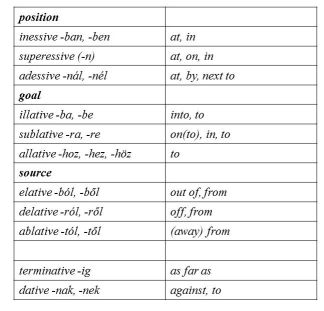
We suggest that languages may view or map the same physical entities in different ways, for example along surface vs. volume or goal vs. passage, etc.
Furthermore, we also find it possible that it is the language specific, inherent coding of the nominal phrase that decides – in many cases – upon the choice of prepositions and case endings. -
An advanced classification method for urban land cover classification
51-57Views:667This manuscript presents a detailed comparative analysis of three advanced classification techniques that were used between 2018 and 2020 to classify land cover using Landsat8 imagery, namely Support Vector Machine (SVM), Maximum Likelihood Classification (MLSC), and Random Forests (RF). The study focuses on evaluating the accuracy of these methods by comparing the classified maps with a higher-resolution ground truth map, utilising 500 randomly selected points for assessment.
The obtained results show that, compared to MLSC and RT, the Support Vector Machine (SVM) approach performs better. The SVM model demonstrates enhanced precision in land cover classification, showcasing its effectiveness in discerning subtle differences in landscape features.
Furthermore, using the precise classification results produced by the SVM method, this study examines the temporal variations in land cover between 2018 and 2020. The results provide insight into dynamic land cover changes and highlight the significance of applying reliable classification techniques for thorough temporal analysis with Landsat8 images.
-
GC-MS studies to map mechanistic aspects of photolytic decomposition of pesticides
11-16Views:240Transformation of pesticides in the environment is a highly complex process affected by different factors. Both biological and physical-chemical factors may play a role in the degradation, whose ratio depends on the actual environmental conditions.
Our study aims to reveal specific details of photolytic degradation of pesticides as important soil contaminants. Significance of these studies is enhanced by the fact that pesticide decomposition may contribute to soil degradation, and have harmful biological effects by degrading to toxic products. The toxicity of the examined pesticides is well known, however very little information is available regarding their natural degradation processes, the quality, structure and biological impact of the degradation products.
The photolytic degradation of frequently applied pesticides of distinctive types (acetochlor – acetanilide, simazine – triazine, chlorpyrifos – organophosphate, carbendazim – benzimidazole) was investigated. A special, immerseable UV-light source was applied in order to carry out photodegradation. The degradation processes were followed by thin layer chromatography (TLC) and mass spectrometry coupled with gas chromatography (GC/MS). EI mass spectrometry was used to identify the degradation species.
Each of the studied pesticides underwent photolytic decomposition, and the detailed mechanism of photolytic transformation was established. At least four degradation species were detected and identified in each case. Loss of alkyl, alkyloxy, amino-alkyl and chloro groups might be regarded as typical decomposition patterns. Deamination occurred at the last stage of decomposition. -
Combined traffic control of irrigation on heterogeneous field
187-190Views:1046In arid areas, such as Hungary, most climate models forecast a rise in water scarcity. Irrigated land accounts for 2% of agricultural land in Hungary, with most irrigation technology being relatively outdated. The aim of this research was to lay the foundation for a combined traffic management system for a water-saving precision irrigation system on an 85-ha field in the Tisza River basin's reference region. High-precision soil maps were created to support the water-efficient variable-rate irrigation system by selecting and selecting areas for different agrotechnical implementations and precision farming zones.
-
Cluster, a potential tool for rural development
195-201Views:338There was a heavy change in the characteristics of the agriculture in the last 20 years. It become a multifunctional, sustainable, organic system, which needs strategic approach. On the problem map of the hungarian agriculture the most importatnt questions are the following: dual charachter of the land structure, to occidentalize the farm structure. To develop the rural areas we need to real markets needs adapted, competitive, local agricultural production. From the ’90s into Europe’s economic development policies integrated the clusters, this research tries to certify, that this system is viable in classic agriculture and able to dissolve the defecinces, to support the aims of rural development.